
Six days before cyclone Hudhud was to strike India’s eastern coast in October last year, the weather office had clearly earmarked its route, identifying which areas it will impact and at what time. Though Hudhud did bring down a lot of structures, authorities had enough time to evacuate people, and limit the death toll to less than 50.
A big earthquake, on the other hand, catches the weatherman unawares, and leaves thousands of corpses in its trail. Even tsunamis come with warnings — scientists can assess whether a vertical earthquake in the ocean will give rise to a tsunami or not — but a quake never does. Landslides and avalanches are sudden events as well, but these are localised phenomena.
The key to predicting a natural event is to understand what triggers it, and what first few signals it sends before finally erupting. An oncoming cyclone or storm, for example, can be sensed by the development of low pressure area of certain strength, and accompanying wind speed and direction.
An earthquake sends such ‘precursors’ too, scientists believe, but so far, they not been able to nail any. The changes are believed to take place several kilometres below the surface of the earth, before the quakes erupt, and scientists have not been able to take their instruments and sensors that deep.
“We have reached outer space, till Mars and beyond, we have reached the ocean bed as well, but haven’t been very deep inside the earth’s crust. That is where the secrets of earthquakes lie, and that is where we need to explore to understand earthquakes,” says Harsh Gupta, former director of Hyderabad-based National Geophysical Research Institute (NGRI) and a doyen of earthquake research in India.
Precursor study, with the objective of predicting an earthquake, is one of the most exciting areas of research in seismology. Koyna, a sparsely-populated town in Maharashtra, has become a unique location for seismic research. It is one of the very few places in the world to experience ‘man-made’ earthquakes. A huge reservoir and dam built in 1962 is believed to have triggered small and big tremors in the area since 1967. Earthquakes, several of them, are a daily affair in about 600 sq km area of this region. The big one had come in 1967, of magnitude 6.3. At least 22 quakes of magnitude between 5 and 6 have been recorded there since, besides several thousand others of lower magnitudes.
Since 1967, after the big quake struck, scientists from NGRI and other institutions have been drilling holes in the earth in Koyna to study earthquakes. The first phase involved drilling holes up to 1.5 km deep and make observations there. “It was done in a non-seismic area. But now we have a lot of information about what happens at that depth,” says Sukanta Roy, project director of the Borehole Geophysics Research Laboratory in Karad. The second phase will begin soon, and will involve drilling holes as deep as 3 km inside the earth.
The ultimate objective, after completion of the final phase, is to go further deep and establish the world’s first deep-earth seismic observatory at 5 to 6 km below the surface to observe changes that happen before and after an earthquake. “In phase-II, we will send our instruments like seismometers, thermal sensors and pore pressure transmitters and try to study the earthquakes. We should have collected enough information by the end of next year to be able to move into the final phase then,” Roy says.
A few years ago, a group of scientists led by Gupta had reported a recurring pattern of small tremors ahead of earthquakes of magnitudes of 4 and above in Koyna. In 2006, the team had ‘predicted’ a 4.3-magnitude earthquake eight days before it had struck. Since then, eight or nine such predictions have come true. But similar patterns have not been observed at other places. In fact, even in Koyna, as Gupta points out, this prediction was successful in only one of the three or four different areas.
“That has been the problem with earthquakes. A few precursors have been found. But the same precursors have not produced earthquakes in other areas,” says K M Rao of the Institute of Seismological Research (ISR), Gandhinagar, that was established after the Bhuj earthquake of 2001.
There have been other instances of earthquakes being predicted elsewhere using dif, most famously near the Blue Mountains in New York in 1970, and in Haicheng city of China in 1975 wherein a six-hour advance warning of a 7.8 magnitude quake resulted in an evacuation that possibly saved about 30,000 lives. A successful earthquake prediction happened in India’s northeast region too in the 1970s. But all these successes have not been repeated, leading to continuing research in this area.
Rao’s own institute has set up a geophysical observatory to discover earthquake precursors. The observatory, equipped with multiple instruments, will keep a watch on changes happening below the surface on as many as 11 parameters when an earthquake happens. These include changes in gravity, magnetism, emission levels of Radon and Helium gases, and fluctuations in water level.
ISR is collaborating with the Dehradun-based Wadia Institute of Himalayan Geology that has been running a similar experiment since 2007. Elsewhere, the Mumbai-based Indian Institute of Geomagnetism set up an observatory in the Andaman and Nicobar Islands last month. Another network exists in the northeastern region as well.
“It is very difficult to say whether or when a precursor can be found and established. Several times abnormal behaviour ahead of an earthquake is observed, but then it is not a signature abnormality. A precursor at one place does not act as precursor at another site. At this stage, we are trying to know more and more about the nature of earthquakes and collect as much information we can,” Naresh Kumar of the Wadia Institute of Himalayan Geology says.
What complicates research further is the fact that changes happening below the earth’s surface are also due to external factors like change of season, planetary motions, atmospheric phenomena, even monsoon. “It’s difficult to know whether a change in any parameter is because of an impending earthquake or external factors,” says Rao.
Research in seismology, he adds, is relatively new, not more than 50-60 years old. “Reasons for earthquakes are buried deep inside the crust where information gathering is very tough. Transformations in the earth’s crust have been happening over millions of years which we do not understand enough. Reliable data is only a few decades old. Still, compared to ‘70s and ’80s when people were pessimistic about finding precursors, there is a new optimism now,” he says.
Catching a quake
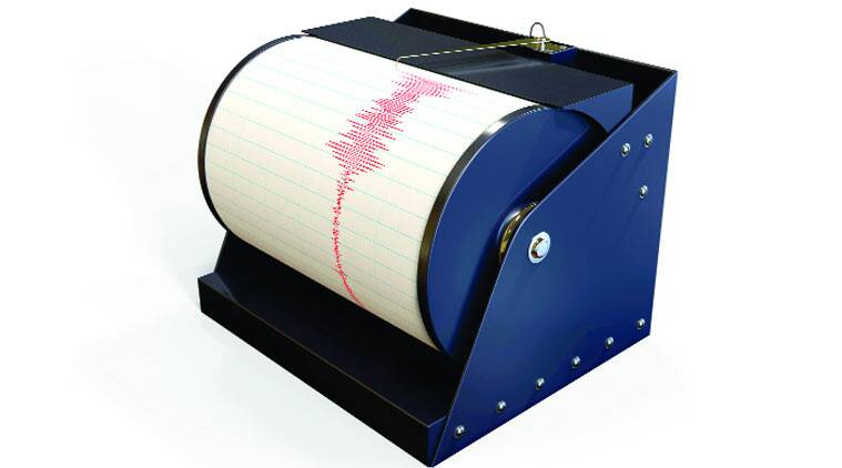
All it takes to measure an earthquake as big as the one that rocked Nepal last week is a 6×6 inch casing buried somewhere in the ground. Around the world, these tiny instruments – seismographs or seismometers – measure quakes big and small by recording vibrations in the ground.
A seismograph is an assortment of sensors, amplifiers and digital circuits packed into a lunchbox like casing. These must be in contact with the ground at all times or better still buried in the earth. The Earth has a magnetic field, so when there is movement of any kind ·horizontal or vertical — an electromagnetic field is created and small currents are generated. These currents, in microvolts, are recorded by seismographs. An amplifier in the same casing amplifies the signals for easy reading. These readings, in digital format, are then transmitted to computers in the laboratory through V-SAT or other communication media.
 Seisomograph
Seismographs are generally deployed on the surface or about 4 to 5 feet below the ground on a concrete surface. There are techniques to go further below, and seismographs have been placed at 50 m, 100 m and even 200 m below the earth’s surface. Siesmographs placed deep down filter out ‘noise’ and have better signal quality but they can’t be taken too deep either. Pressure, temperature and other varying conditions interfere with the operation of the seismograph.
1,000 is the estimated number of seismographs currently installed all over the country. Different research institutions and organisations set up their own seismic stations and there is no exact number.
 Seismometer
Modern seismographs were deployed on a mass scale from the mid-1960s. But they have been in circulation from the late 19th century. In India, the first instrument for measuring earthquakes was installed in Alipore, Kolkata, in 1898, after the big earthquake of 1897 in Shillong. The next year, similar instruments were set up in Colaba (Mumbai) and Madras (then Chennai). The instrument in Madras was later shifted to Kodaikanal. After the Dharamsala earthquake of 1905, more instruments were set up around Mumbai, Agra and Dehradun.