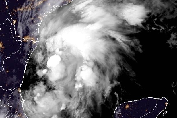
Sept. 12 (UPI) — Tropical Storm Nicholas formed in the southwestern Gulf of Mexico on Sunday, threatening to bring heavy rainfall to Mexico and Texas.
In its 10 p.m. CDT update, the National Hurricane Center said Nicholas was located about 170 miles east-southeast of La Pesca, Mexico, and 260 miles south-southeast of the mouth of the Rio Grande.
It was traveling north at 2 mph and carried maximum sustained winds of 40 mph.
A hurricane watch was in effect for Port Aransas to Free Port, Texas, while a tropical storm warning was ordered for the mouth of the Rio Grande to High Island, Texas, and from Barra el Mezquital to the U.S.-Mexico border.
A tropical storm watch was in effect for east of Hight Island, Texas, to Sabine Pass.
A storm surge warning was in effect for Port Aransas to San Luis Pass, Texas, as well as for Aransas Bay, San Antonio Bay and Matagorda Bay.
A storm surge watch was in place for the mouth of the Rio Grande to Port Aransas, Texas; San Luis Pass, Texas, to Rutherford Beach, La., including Galveston Bay; and for Baffin Bay and Corpus Christi Bay.
Nicholas was forecast to continue moving north while picking up speed. By late Monday, it is expected to shift in direction and travel north-northeastward toward the Texas coast.
“On the forecast track, the center of Nicholas will pass near or just offshore the coasts of northeastern Mexico and South Texas on Monday, and move onshore along the coast of south or central Texas coast Monday night or early Tuesday,” the NHC said.
Nicholas is expected to produce 5-10 inches of rainfall with isolated amounts of 15 inches in portions of coastal Texas and southwest Louisiana and 2-5 inches in eastern portions of the Mexican state of Tamaulipas.