Aug. 25 — The peak of hurricane season is off to a fast start and meteorologists are keeping an eye on several tropical features in the Atlantic basin that could develop in the coming days.
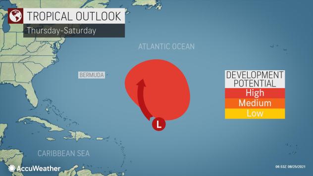
Forecasters were monitoring three tropical waves that could become the next named system in the Atlantic basin. One is located in the Caribbean and the other two are over the open waters of the Atlantic.
“As of Tuesday, a tropical feature over the Caribbean is of the most immediate concern for impacts to land, life and property,” said AccuWeather Senior Meteorologist Alex Sosnowski, who added that the system was “looking poorly organized and may not take shape until the latter part of the week or this weekend.”
Elsewhere in the Atlantic, the skies are teeming with activity — and not just of the tropical variety. Large amounts of Saharan dust have been wafting off the northwest coast of Africa in recent days, some of which reached South Florida over the weekend, making for milky sunsets.

A satellite image shows the confluence of Saharan dust and brewing tropical activity over the open waters of the Atlantic Ocean on Tuesday. Image courtesy CIRA/RAMMB
Satellite imagery Tuesday showed clouds of dust in both areas where tropical activity is brewing.
Sosnowski also pointed out two other features brewing far out over the Atlantic that will also have some atmospheric hurdles to overcome in order to reach tropical storm force and be given a name.
Any of the three could become the next named tropical storm in the basin, which would be Ida, followed by Julian and Kate.
One of the tropical waves was located about 1,000 miles northeast of the Leeward Islands on Tuesday, moving northwestward and aiming more for Bermuda than the Caribbean. The exact timing of a cold front sweeping through the western Atlantic will determine how close this feature can get to Bermuda.
 |
The other feature in the Atlantic Ocean, as of early Wednesday morning, was located several hundred miles southwest of the Cabo Verde Islands. The position of the tropical wave, almost near the equator, could play a role in its chances of strengthening.
“The current problem with this easternmost feature is how close it is to the equator,” Sosnowski added, “In this part of the ocean, several other physical forces, in addition to nearby dry air, make strengthening less likely unless it is able to drift hundreds of miles northward.”
Depending on how fast the tropical wave moves, this northward jog could take several days to occur.
As both of these features move northwestward across the basin throughout the week, AccuWeather meteorologists will be monitoring for the chances that either wave could impact land.
However, forecasters say that the chances of impacting the United States, as of Tuesday, are rather unlikely.
 |
Following Henri’s deluge across the Northeast, a change in the weather pattern is expected this week, which is likely to bring a different outcome.
“Both central Atlantic features are likely to be blocked from traveling too close to North America. This is due to the position of a high pressure system near Bermuda and a forecast ripple in the atmosphere that would create southerly steering breezes near the Lesser Antilles,” Sosnowski said.
While the Atlantic hurricane season starts on June 1, most of the storms tend to develop later in the summer and early fall. The peak of the season is considered mid-August to late September or early October.
According to AccuWeather Hurricane Expert Dan Kottlowski, about 80% of tropical storms and hurricanes form in a 45-day window between mid-August and late September, due to the ripe atmospheric conditions in the basin.
That has already been evident so far this year, when Tropical Storm Fred, Hurricane Grace and Hurricane Henri all formed in less than a week, from Aug. 11 to Aug.17.
 |
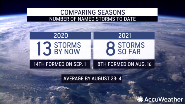
So far in 2021, the Atlantic hurricane season has been more active than normal. Henri became a named storm on Aug. 17, a staggering 38 days ahead of the “H” storm’s average arrival (Sept. 24). Despite this, this tropical season is still running behind last year’s record-shattering hurricane season, which produced Tropical Storm Hanna on July 24.
Even if all three of the tropical features currently being monitored in the Atlantic basin were to be named in the next couple of days, it would still be at least a week behind the pacing of the 2020 season — this time last year, there were already 13 named storms.