By Matthew Cappucci
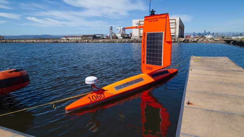
For decades, atmospheric scientists have targeted hurricanes by land, sea and air, flying airplanes into their cores to collect measurements from the belly of the beast. Now, a joint venture between Saildrone and the National Oceanic and Atmospheric Administration is taking a new approach: drive winged, robotic surfboards into the path of an approaching storm.
The novel technique builds upon years of exploration by Saildrones, which measure ocean water temperature, salinity and chemical composition, and can map the ocean floor. They even are equipped with acoustic sensors that can detect the presence and quantity of fish in a given area.
Conventional Saildrone probes in the past haven’t been durable enough to sustain the harsh conditions found near the center of hurricanes, but now the company is introducing a redesign that should allow it to endure a high-end storm. Five of Saildrone’s smaller units – the 23-foot Saildrone Explorer – will be positioned in the Atlantic’s hurricane belt this season, which began Tuesday.
“Our goal is to get new insights into hurricane intensity and tracking with data that hasn’t been recorded with surface measurements as close to the center of a hurricane as possible,” said Richard Jenkins, Saildrone’s founder and chief executive.
The company is working with funding from and in cooperation with NOAA, which, along with the National Hurricane Center in Miami, will offer advice on where the units should be deployed and stationed.
Ordinary Saildrone Explorers are rated to operate in winds as high as 50 knots, or near 60 mph, but winds in fierce hurricanes routinely exceed 115 mph. Jenkins explained that the wing, which sits atop a mast and holds solar panels and instruments, is usually the first failure point in high winds. That forced the company to adapt.
“[What we have now is] the same vehicle with a different wing,” Jenkins explained. “It’s really designed to be as robust as it possibly can be. It really has to survive that and be back on. With the modifications and new wings, there are five vehicles. Building the five new wings . . . that took us about three months.”
The smaller, more durable wings are designed to withstand 100 mph-plus winds, large, breaking waves and “being buried by big waves and tumbled,” Jenkins said.
He says that the small wing makes the unit less top-heavy and more aerodynamic.
“It’s about half the size [of the original],” Jenkins said. “It reduces weight, the center of gravity is lower; it’s able to withstand stronger winds. It’s like how fast planes have small wings, like fighter jets, and slow jets have bigger winds.”
Saildrone is planning to deploy three units out of the Caribbean and U.S. Virgin Islands, and two from the shores of Florida. They can travel under their own power at 1 to 2 mph.
Christian Meinig is the director of engineering development at NOAA’s Pacific Marine Environmental Laboratory. He explained that this year will largely feature testing for what will hopefully become a routine deployment year after year.
“It’s possible that the Saildrones will get damaged or even disabled under these conditions, but we will learn and continue to advance the designs and tactics,” he wrote in an email.
The teams are excited at the prospect of understanding more about heat exchange within hurricanes, since the probes can gather readings in places that ships just can’t go. While buoys can and do collect data, Saildrones have a more expansive instrumentation arsenal and are mobile, compared to buoys, which are anchored in place.
“They key here is the surface fluxes, the . . . rate of change of heat, moisture, carbon, etc. [from the sea surface to the atmosphere above],” Jenkins said. “It’s the rate of change of heat and moisture in and out of the surface that’s driving the hurricane.”
The Saildrone observations will be complemented by data from underwater gliders, which can dive below the surface to determine how deep a layer of warm water extends. The scientists hope to learn how that vertical profile of the water changes over time and after the passage of a storm.
Each unit is also outfitted with a system of cameras that will observe sea spray and foam – a seemingly trivial byproduct of swarming seas that plays an enormous role in heat transfer to the atmosphere.
“The spray coming off the waves is very important in the hurricanes,” Jenkins said. “Our goal is to use images to understand how the spray and foam is characterized, which is crucial to the atmosphere and ocean exchange.”
Those are measurements that haven’t been taken before, and present a bit of a gap in present hurricane modeling and understanding.
“I wouldn’t say our current understanding is inaccurate, but we just don’t know,” Jenkins said. “If you can’t measure the conditions and the fluxes, you just don’t know.”
Meanwhile, Saildrone is also working with their larger models, the 72-foot Surveyor, to map bathymetry, or the slope and topography of the sea floor.
“Mapping the sea floor is very important for storm surge,” Jenkins said. “There are large parts of the Florida shelf just completely unmapped where storm surge is happening. We’re hoping to get a whole fleet of Saildrones out to the shore to start mapping and to help people prepare.”
Each will be equipped with sonar and, since they are larger units, can run at 6 knots, or 7 mph.
“They . . . can map the seafloor with same resolution of a ship, and we can run them 24-7,” Jenkins said.
With tropical weather experts predicting an active hurricane season, odds are Jenkins and his team will have plenty of data to collect.
The Washington Post